
Transit Tour Guide:
Twin Cities
The Twin Cities of Minneapolis and Saint Paul do not seem to get the attention that Dallas, Denver, or Salt Lake City have for their major transit expansions. But, in their quiet Midwestern way, they have built one of the best transit systems in the country.


Downtown Minneapolis is the largest hub of the regional transit system.
The Blue and Green light rail lines run past the football stadium (a good photo spot [1], with the giant glass wall of the stadium as a background in one direction and the downtown skyline in the other) and down 5thStreet [2[, terminating at the Target Field Station. Target field is also the end of the Northstar commuter rail line. The commuter rail platform [3] offers nice view of trains entering and leaving the station and of light rail trains passing overhead.
Nicollet Mall [4] is a 12 block transit mall, just completely rebuilt and definitely worth a visit. It’s easy to walk the whole length, or hop on and off the bus to see multiple spots. The skywalks, open 7 days a week, offer an overhead view. The mall carries 8 different local bus routes. Buses that terminate Downtown are free to ride within the mall and change their destination signs to “free ride” as they enter Downtown. (Some routes end at the north end of the mall, and some at the south end, so there are free buses in both directions, with one set of routes free northbound and another set free southbound.)
Downtown is also the hub of a large regional commuter bus network. Many of these routes use Marquette and Second Avenue [5]. These were rebuilt in 2009 for better transit as the “Arq2” project. When in full operation at weekday rush hour, the streets have two bus lanes only in one direction, with two regular traffic lanes in the opposite direction Buses stop every other block, and each block has 4 bus bays, marked with letters. The bus choreography, and crowds of riders, are fascinating to watch. The skywalks are a great way to see what’s happening.


The Blue Line, from Downtown Minneapolis to the Mall of America, was Minneapolis’ first light rail line. Most of the route runs alongside Hiawatha Avenue, a partially grade separated highway.
The Martin Olav Sabo Bridge [6] takes the Midtown Greenway above the line, with spectacular views of light rail and the downtown skyline. It’s walking distance from the Lake St.- Midtown station, but the best way to experience it is on a bike along the Midtown Greenway.
The elevated Lake Street-Midtown [7] station has a nice view of Downtown from the platforms, adjacent transit-oriented development, and busy crosstown bus stops.
Minnehaha Regional Park offers another nice view of the line (and a great urban waterfall.)
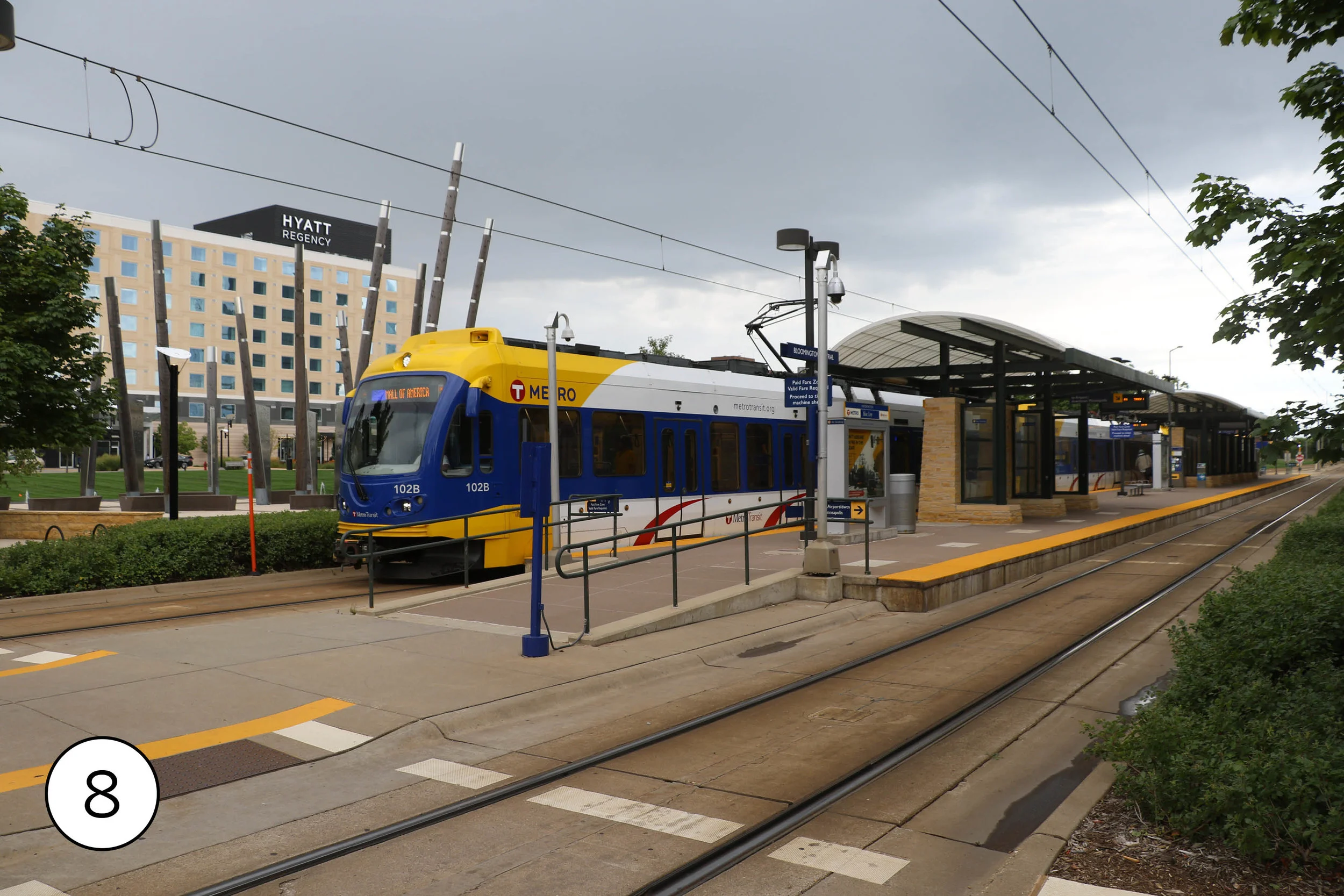
South of the airport, the Blue Line runs through Bloomington on its way to the Mall of America. The Bloomington Central stop [8] has new development centered on a new park.


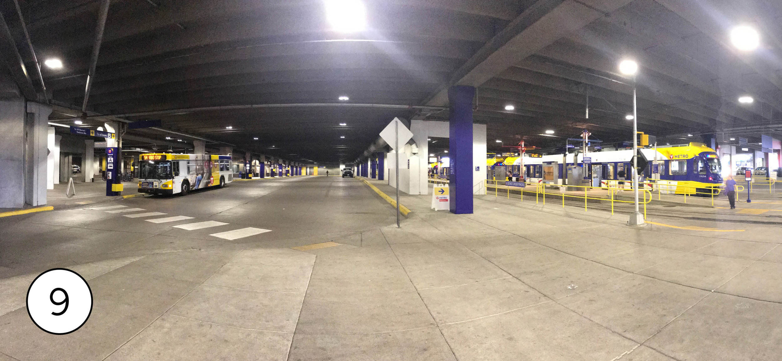
The Red Line connects to the Blue Line at the Mall of America transit center [9], tucked into the ground floor of one of the gigantic mall’s parking garages. It’s not in the book as BRT since it doesn’t have real dedicated lanes (just highway shoulders and curbside lanes shared with turns) but it probably has the fanciest bus stops [10] anywhere in the United States – enclosed heated, with level boarding at “docks” with sliding glass doors and even skywalks directly connected to the stops. This is definitely overkill for a line that carries less than 1000 people a day, but it’s worth visiting to admire what a bus stop could be.

The light rail Green Line runs from Downtown Minneapolis to Downtown Saint Paul. It’s completely different in character from the Blue Line, running down city streets – primarily University Avenue [11].
At the University of Minnesota, around East Bank Station, the Green Line is in a transit mall right through campus.
At Prospect Park station [12], where the train turns onto University, a huge concrete grain elevator anchors one end of the station, and new mixed use development the other, with a community garden in between and a landmark water tower in the skyline. Just north of the station, the light rail runs alongside a very unusual transit facility: a dedicated busway along rail right of way that is used by shuttle buses that connect the University of Minnesota main campus. To the Saint Paul campus 3 miles away.
Raymond Avenue station [13] has a photogenic cluster of old warehouses turned into lofts.
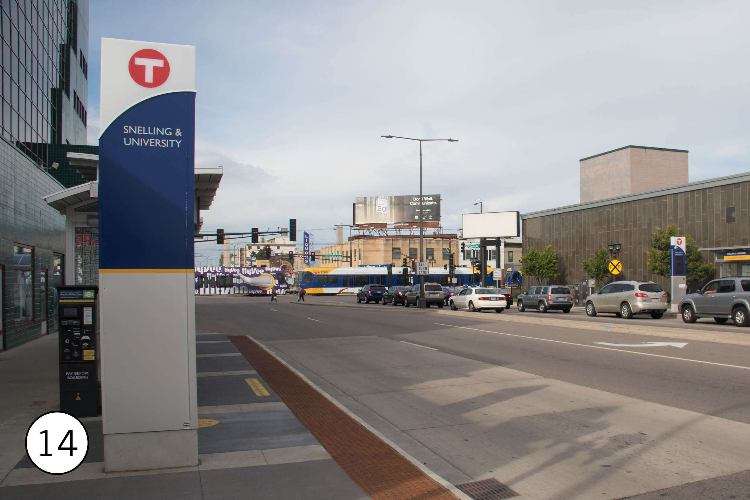
At Snelling [14], the Green Line crosses the A Line (see below.) A brand new soccer stadium was built on the site of an old bus barn, and the surrounding strip malls are planned to be redeveloped as TOD.


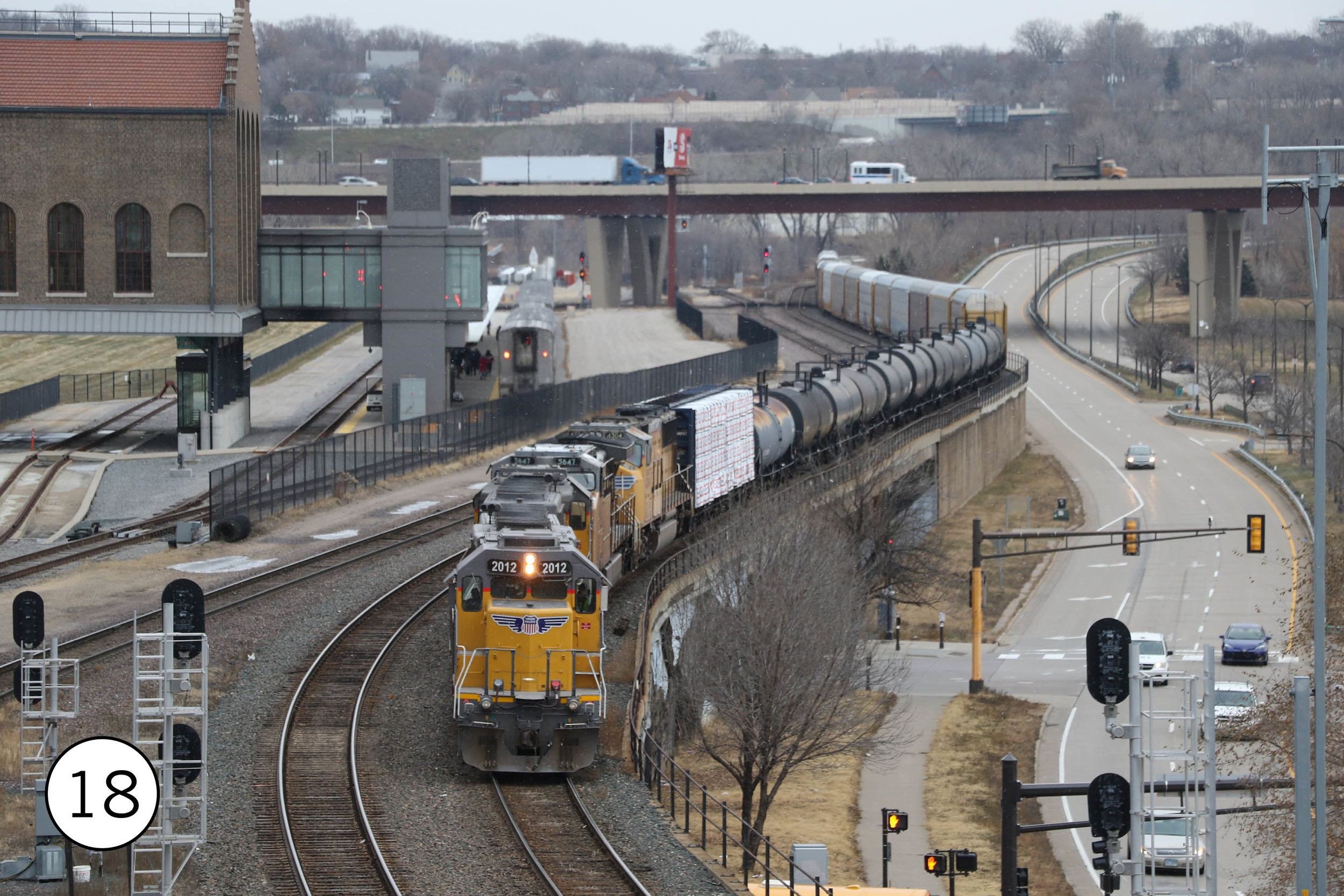
In Downtown Saint Paul, the Green Line line leaves University, curves around the state capitol (10th Street Station [15] offers a nice view) and then runs into Downtown. Central Station [16] – cutting diagonally across a city block -- is major bus transfer point. Downtown has several very nice bus stops – including heaters – provided by Metro Transit, but also one very over-the-top stone shelter at 6th and Jackson, nicknamed the “Taj Mahal” [17]. The Green Line stops in front of the historic Union Depot [18], completed in 2012 and restored in 2012. The depot itself now serves as the Twin Cities’ Amtrak stop, an intercity bus terminal, and a transit center where several local bus routes lay over.


The A line [19] is one of the best bus routes in the country – all day, every day frequent service, limited stops, a simple route, signal priority, off-board fare collection, all-door boarding, well designed stops, and great passenger information. Metro Transit calls it “arterial BRT” and it increased ridership by a third over the previous local bus. It connects to the Green Line at Snelling and the Blue Line at 46th. (A second ABRT route, the C Line, just opened in Minneapolis.)

The Metro bus network is one of the best in the country – the Twin Cities are one of the places where riding the bus seems normal. Twenty-five percent of bus riders in the Twin Cities have an annual household income over $50,000. The neighborhoods south of Downtown Minneapolis, built around streetcar lines and now served by frequent buses, are still transit-friendly. Eight routes come together at Uptown Transit Station [20], where riders can wait in enclosed waiting rooms and board under wide canopies. There’s a bike repair station, too, for people riding the Midtown Greenway, which passes under the station. The center straddles the street so buses do need to go out of their way to stop. [10]

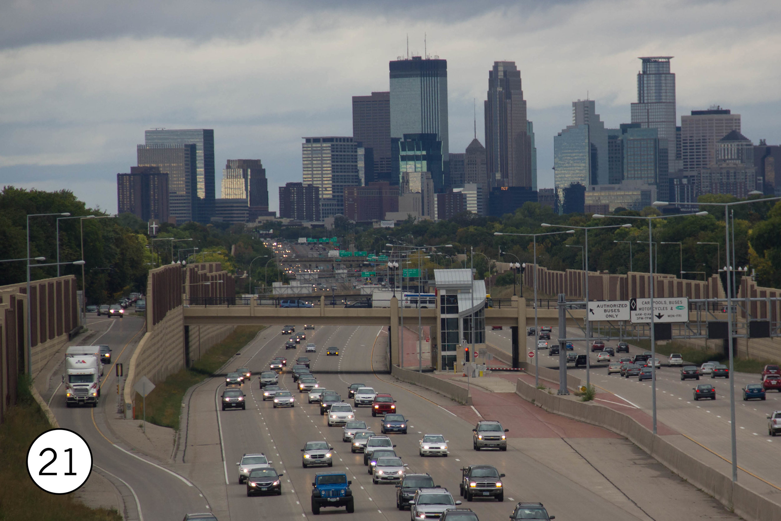
At 46th Street [21], a station in the median of the I-35W, which is in a trench here, allows buses to stop without leaving the HOV lanes in the center of the freeway. Before reaching the stop’s center platform, the bus lanes cross over each other so that right side bus doors can open on to the platform. Local buses stop on the street above for easy connections. This will be part of the Orange Line BRT, opening in 2021.
The Midtown Greenway [22] is an amazing bike facility, passing under the streets of Minneapolis in the trench of an abandoned rail line. Frequent ramps connect to the surrounding neighborhoods and the new development that has sprung up along the path. The Greenway connects to the Blue Line at Lake Street / Midtown Station and to the Uptown Transit Station. At Midtown Global Market, a reused Sears building, a bike store opens directly onto the path.

Getting around
Metro Transit offers a $5.00 day pass, available at rail station ticket vending machines and on the Metro Transit app.
The NiceRide bikeshare system has great coverage in Minneapolis. Unfortunately, it no longer covers Saint Paul.
Getting there
The Blue Line runs from the airport to Downtown Minneapolis. The #54 offers direct service from the airport to Downtown St. Paul.
Amtrak’s Empire Builder stops at St. Paul Union Depot (on the light rail Green Line) once a day in each direction on its way from Chicago to Seattle and back. The train takes 8 hours to/from Chicago and 6 to/from Milwaukee, arriving in St. Paul 10:00 pm, and departs St Paul at 8:00 am. There are also multiple intercity buses to both of those cities.