
The second edition of Trains, Buses, People is a book by Christof Spieler that analyses every rail transit and bus rapid transit system in the United States and Canada -- and shows how to make transit successful.
““Those who love the minutia of how individual cities handle transit will return time and again to the heart of the book: detailed discussions of the top 47 transit systems in the United States. Perhaps even more useful, though, are the introductory sections and the conclusion, which provide invaluable advice for improving our country’s at times poorly conceived, under-funded, and under-utilized transit systems.””
“For all of their hardcore infrastructure, urban transit networks are essentially human creations, and understanding what makes them successful is essential for building successful cities. Supported by urban histories and incisively presented data, Christof Spieler sets the rules of engagement for effective transit and offers a roadmap for achieving it.”
“Transit planners, elected representatives, and transportation enthusiasts should all find something to love or learn in this honest and expansive status report. Most of all, Spieler hopes the book helps demystify the basics of sound decision-making. “We often treat transit like a highly technical and complicated set of choices,” he said. “But what makes it good is pretty straightforward. It’s about where to put a service, and what to prioritize about it.””
“Christof Spieler was the driving force behind Houston’s transit transformation, but he’s also one of America’s great transit travelers, a careful observer of history, technology, geometry, and politics. This book is an atlas of beautiful detail about 47 U.S. cities, but it’s also a call to action, demanding clearer and more effective transit planning and advocacy.”
“The author combines detailed knowledge and a refreshing frankness. Not all the problems he identifies are transit-specific: “The city of Detroit is poor not because of a lack of economic activity or money; it is poor because that activity has been moved to suburbs that do not want to share their wealth with the city.””
“This book is comprehensive enough to be a resource for transit professionals, but delivered in readable, straightforward language; an objective look at the state of transit by a passionate advocate.”
Most of the time, transit discussions are about TRAINS or BUSES: what technology is best?
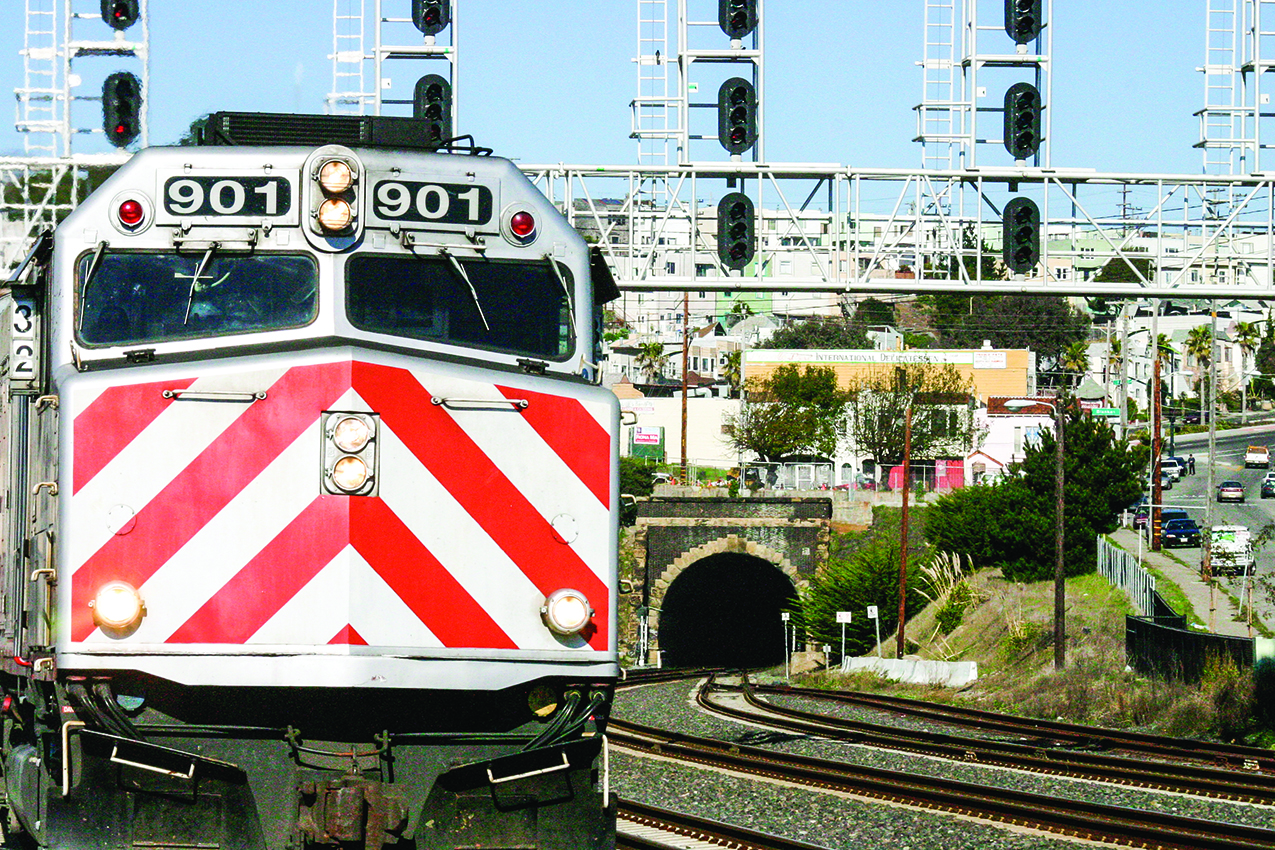


...but transit is really about PEOPLE. Riders care about walkability, connectivity, frequency, travel time, reliability, capacity, and legibility much more than they care about steel wheels or overhead wires.


Most of all, people care about whether transit goes where they want to go. The most important decision in transit is what places to connect.
That's actually pretty easy:
Find where the densest places are
(The more dense the area around a transit station is, the more people can use it)

Identify centers.
(Major employment centers, hospitals, universities)

Connect the dots.
(One center to another, passing through those dense areas)
Unfortunately, we in the United States and Canada are often not very good at this. In city after city, major transit lines actually avoid dense areas — the places where the most people want to go.

That also hurts the people who need transit most. In many cities, the parts of the transit network that serve low income residents and Black and Hispanic neighborhoods is nothing more than local buses stuck in traffic while much lower ridership lines to suburban areas have rail or express us with better infrastructure and more reliable service. Many systems are optimized to serve white collar commuters at the expense of service workers and people who rely on transit for all their trips. And some of the highest ridership systems are not fully accessible to people in wheelchairs.

“Trains, Buses, People” focuses on how these decisions get made, and why. Through maps, data, photos, diagrams, descriptions, and analysis, looks at57 metro areas in the United States and Canada — the ones that have rail or bus rapid transit — and considers why they built the transit that they did and how well it is working. It lays out what makes transit successful — and the political issues, misconceptions, and policy limitations that hold it back.
PART 1: THE ROLE OF TRANSIT IN THE US AND CANADA
The History of Transit
Drawing a Line
Networks
Modes
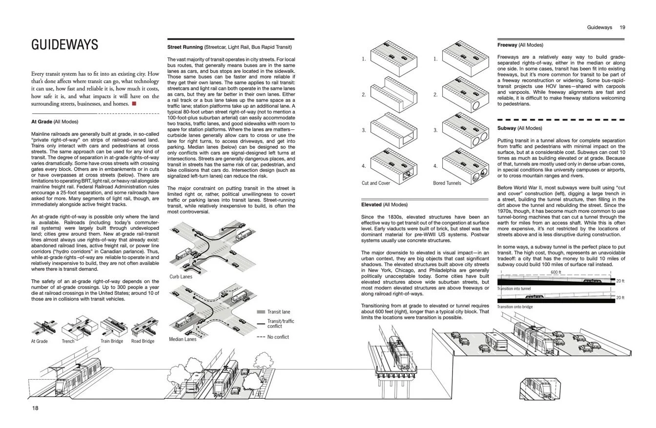
Guideways
Stations
Fares
Governance
Funding
Riders and Destinations
Hopes and Fears
NEW IN THE SECOND EDITION: Fares, Funding, Networks, Guideways, Stations, and Riders and Destinations, and expanded content in other sections.
Transit in the US exists in a very particular context that's different from Europe, Asia, or Latin America. Our history (like the postwar suburban boom), our politics (like the complicated issues of race), and our legal structure (like the difference between Amtrak and commuter rail) shape what we build. And while Canada is similar in some ways, it has fundamental differences that show up in the structure of systems and ridership. This section discusses the context of transit. its purpose, how it has developed over time, the common types of transit, that basic technologies it uses, the political discussions around it, and how transit is funded and built.
PART 2: BASICS OF SUCCESSFUL TRANSIT
Density
Activity
Walkability
Connectivity
Frequency
Travel Time
Reliability
Capacity
Legibility
Inclusivity
Good Ideas from Abroad

NEW IN THE SECOND EDITION: Inclusivity
Regardless of politics, governance, and local context, the fundamental keys to making transit useful -- and thus attracting riders -- are universal. This section goes through what makes transit work well, with lots of examples, good and bad.
PART 3: METRO AREAS
The Best and the Worst
The 57 Metro Areas
Conclusion: A Transit Agenda for the Future of our Cities

NEW IN THE SECOND EDITION: 8 Canadian metro areas, San Juan, and Indianapolis, and updates to the other metro areas to reflect new extensions and add more photos and content.
57 metropolitan areas in the United States and Canada have rail transit or bus rapid transit. This section profiles all of them, and the 130 individual systems within them.
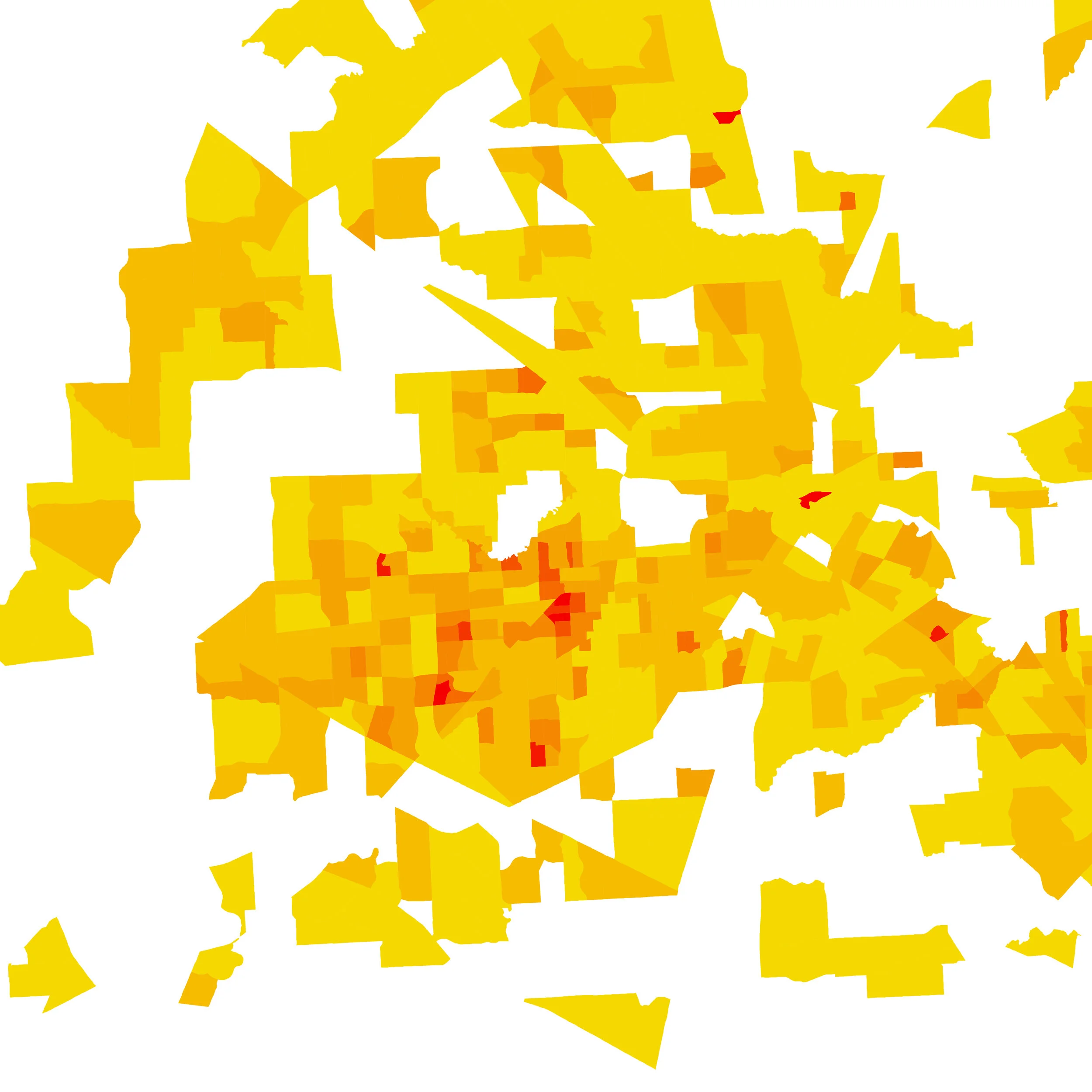
For each metropolitan area the book shows 2 maps. The first shows the physical form of the transit, showing different modes and whether they are within a street, at grade, elevated, in a subway, or in a freeway. The second shows how well the systems serve people and jobs, with the area within walking distance of frequent transit overlaid on population and employment density (see samples here.) All 94 of these maps are at the same scale, making it easy to compare one city to another.
For each system, the book has a profile with key information: size, ridership, age, and level of service. Large, small, high performing, and low performing systems are specifically called out, making it easy to make comparisons and find good examples.
In addition to the data, each metro area has descriptions, photos, analysis, and diagrams pointing our what's unique about that city, whats working and what isn't, and why that city made the decisions it did. There are a lot of thing other cities should emulate, and some cautionary tales as well.
At the beginning of this section, there's a list of similar systems -- to help find good useful comparisons -- and best and worst systems. At the end there's a sample of projects that should be built around the United States.
Here’s a sample Metro Area section, for a city’s that’s not in the book, Munich Germany: pdf file.

"Trains, Buses, People" measures success not by how much transit a city has built, but by how useful the transit is.
And, in every city, it finds opportunities to improve transit.
If we have more intelligent conversations about transit we will build better, more equitable, transit, and we can make millions of people’s lives better every day.
Buy the book
published by Island Press
OTHER WRITING
more analysis of transit